|
53rd
Street Central Hyde Park TIF District Maps
A
service of the Hyde Park-Kenwood Community Conference, its Development
Zoning and Preservation task force, and its website, www.hydepark.org.
Help support our work as watchdog, forum and clearing house: Join
the Conference. |
Back to TIF News.
To current general zoning maps. Zoning
Reform. Other
general and business maps.
See close up of Harper Court
in Harper Court Sale
home.
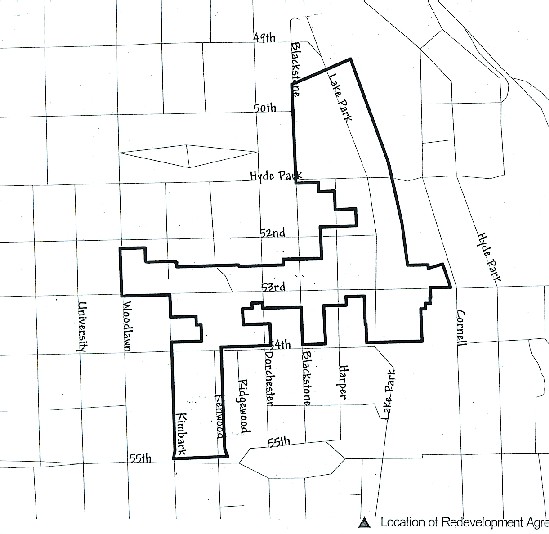
Map 1 is essentially
a generalized final boundary, with minor changes along the Metra/Canadian National
tracks. (Except for saying "Proposed", the map is essentially accurate
except for showing the Osteopathic Center, now residential development, and
not showing 53rd Street now opened to Cottage Grove with jogs.) The second
map is more specific.
Some institutions
near the district could not be included because of strict rules excluding properties
not meeting standards of potential deterioration/dilapidation, deleterious land
use, and real estate (tax) valuation stagnation. Excluded properties include
upscale homes between the district's north edge, Blackstone Branch Library,
Kenwood Park, residential property between the district's west boundary at Woodlawn
Avenue and Kozminski School, properties between Cornell and Hyde Park on 53rd,
(some may now wish) the new Hyde Park Art Center building at 5220 Cornell. Of
course, the thriving and recently renovated Hyde Park Shopping Center could
not qualify.
Map 1
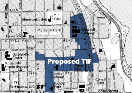
Map 2, Neighborhood Capital
Budget Group (based on Chicago Department of Planning and Development records?)
NCBG has a GIS program and a data bank to
superimpose economic, tax, and demographic data on such maps. This service is
available to its members, attn: Pat Nolan. (Such data tends to reflect reporting
and release from several years back.)